Item 3824Berlin
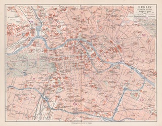
Lithograph, 1901. 240mm by 300mm (sheet). German city plan of Berlin, Germany. Central vertical fold as issued.

Lithograph, 1901. 240mm by 300mm (sheet). German city plan of Berlin, Germany. Central vertical fold as issued.
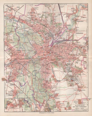
Lithograph, 1901. 300mm by 240mm (sheet). German city plan of Leipzig, Germany. Central horizontal fold as issued.

C1880. Lithograph. C1880. 390mm by 280mm (image). Detailed map of New Zealand, with insets of Tasmania and map showing position of Australia and New Zealand. Shows roads, rivers, mountains, lakes, etc. Counties delineated with a key.Adam & Charles Black were among the leading publishers of atlases and travel books in.....

1896. Colour lithograph. 1896. 335mm by 470mm (sheet). From Bacon's 'New Complete Atlas of the World'. George Washington Bacon (1830-1922) was a London-based book and map publisher active in the mid to late 19th century. Central fold as issued. '113' top right hand corner. CONDITION : Slight waviness along central.....

1896. Colour lithograph. 1896. 470mm by 335mm (sheet). From Bacon's 'New Complete Atlas of the World'. George Washington Bacon (1830-1922) was a London-based book and map publisher active in the mid to late 19th century. Central fold as issued. '88' bottom right hand corner. CONDITION : Slight waviness along central.....

1896. Colour lithograph. 1896. 335mm by 470mm (sheet). From Bacon's 'New Complete Atlas of the World'. George Washington Bacon (1830-1922) was a London-based book and map publisher active in the mid to late 19th century. Central fold as issued. '118' top right hand corner. CONDITION : Slight waviness along central.....

1792. Copper-line engraving. 1792. 420mm by 750mm (map) 590mm by 920mm (frame). Map of area between Solander Point Botany Bay and the North Arm, Broken Bay. Relief shown by hachures and bathymetric soundings. Tooley 742.Some overall toning. Some repairs along splits in folds.Framed with acid free mount in simple black.....

1804. Copper-line engraving with original hand-colouring. 1804. 490mm by 550mm (platemark). Large decorative map by Jones, Smith & Co. for Smith's New English Atlas. The first map of the county to show longitudes measured from the meridian of Greenwich. Slight toning along central fold."

1804. Copper-line engraving with original hand-colouring. 1804. 550mm by 490mm (platemark). Large decorative map by Jones, Smith & Co. for Smith's New English Atlas. The first map of the county to show longitudes measured from the meridian of Greenwich.

1874. Lithograph with original colouring. 1874. 540mm by 435mm (sheet). From FE Hiscocks' 'New Victorian Counties Atlas', published in Melbourne by George Robertson in 1874. There is a central horizontal fold as issued. Some old ink marks as can be seen in the photo."

1909. Colour lithograph. 1909. 340mm by 525mm (sheet). From Bacon's Australian Atlas of the World. George Washington Bacon (1830-1922) was a London-based book and map publisher active in the mid to late 19th century. Central vertical fold as issued.

1909. Colour lithograph. 1909. 345mm by 255mm (sheet). From Bacon's Australian Atlas of the World. George Washington Bacon (1830-1922) was a London-based book and map publisher active in the mid to late 19th century. CONDITION : One tiny abrasion.

1909. Colour lithograph. 1909. 345mm by 265mm (sheet). From Bacon's Australian Atlas of the World. George Washington Bacon (1830-1922) was a London-based book and map publisher active in the mid to late 19th century.

1909. Colour lithograph. 1909. 345mm by 265mm (sheet). From Bacon's Australian Atlas of the World. George Washington Bacon (1830-1922) was a London-based book and map publisher active in the mid to late 19th century.

C1930. Chromolithograph. C1930. 990mm by 720mm (image) 1240mm by 970mm (mount). General Map of Sydney and Environs showing Localities, Railways, Tramways and Principal Roads.' Chromolithograph, circa 1930.Compiled and published by HEC Robinson Ltd, 221-223 George St, Sydney.Acid free mount."

1847. Steel-engraving with original hand-colouring. 1847. 240mm by 370mm (platemark). A detailed engraved map of the English county with title, scale, and key. Decorated with an uncoloured engraved view of 'St George's Chapel, Windsor'. Published by I. Slater, Fleet Street, London & Fountain St. Manchester."

1847. Steel-engraving with original hand-colouring. 1847. 370mm by 240mm (platemark). A detailed engraved map of the English county with title, scale, and key. Decorated with an uncoloured engraved view of 'Carlisle Cathedral'. Published by I. Slater, Fleet Street, London & Fountain St. Manchester."

1847. Steel-engraving with original hand-colouring. 1847. 370mm by 240mm (platemark). A detailed engraved map of the English county with title, scale, and key. Decorated with an uncoloured engraved view of 'Ashborn Church'. Published by I. Slater, Fleet Street, London & Fountain St. Manchester."

1847. Steel-engraving with original hand-colouring. 1847. 240mm by 370mm (platemark). A detailed engraved map of the English county with title, scale, and key. Decorated with an uncoloured engraved view of 'Durham Cathedral'. Published by I. Slater, Fleet Street, London & Fountain St. Manchester."

1847. Steel-engraving with original hand-colouring. 1847. 370mm by 240mm (platemark). A detailed engraved map of the English county with title, scale, and key. Decorated with an uncoloured engraved view of 'Hereford Cathedral'. Published by I. Slater, Fleet Street, London & Fountain St. Manchester."

1847. Steel-engraving with original hand-colouring. 1847. 370mm by 240mm (platemark). A detailed engraved map of the English county with title, scale, and key. Decorated with an uncoloured engraved view'. Published by I. Slater, Fleet Street, London & Fountain St. Manchester."

1847. Steel-engraving with original hand-colouring. 1847. 370mm by 240mm (platemark). A detailed engraved map of the English county with title, scale, and key. Decorated with an uncoloured engraved view of 'Godmanchester Church'. Published by I. Slater, Fleet Street, London & Fountain St. Manchester."

1847. Steel-engraving with original hand-colouring. 1847. 370mm by 240mm (platemark). A detailed engraved map of the English county with title, scale, and key. Decorated with an uncoloured engraved view of 'Chepstow Church'. Published by I. Slater, Fleet Street, London & Fountain St. Manchester."

1847. Steel-engraving with original hand-colouring. 1847. 370mm by 240mm (platemark). A detailed engraved map of the English county with title, scale, and key. Decorated with an uncoloured engraved view of 'Peterborough Cathedral'. Published by I. Slater, Fleet Street, London & Fountain St. Manchester."

1847. Steel-engraving with original hand-colouring. 1847. 370mm by 240mm (platemark). A detailed engraved map of the English county with title, scale, and key. Decorated with an uncoloured engraved view of 'St Mary's Church, Nottingham'. Published by I. Slater, Fleet Street, London & Fountain St. Manchester."